This waterfall is no longer accessible by dry land. No Trespassing signs have been posted and I'm told that Gary Walls Rd. is now a NO TRESSPASSING road. So, just stay out. Sorry!
This information is for archive and reference only!
(39.626548 -79.722478)
While all the below information is pertinent, in February 2020 I learned that The Nature Conservancy now owns the property and it is no longer a no trespassing area, however, I do not see this land listed on their website, unless Cheat Canyon Wildlife Management Area encompasses the area. So, be advised. This may still be private property.
From Interstate 68, take either exit 15 or 23, depending on which direction you are coming from. Continue on County Route 73 until you reach Laurel Run Road. This is a paved road, but it is a bit rough. After a half mile, take the first left on to Gary Walls Road. This is a narrow unpaved, road, and has several rough spots. The road winds its way through farm lands. After a mile, the road becomes very rough and starts to descend. This is as far as I felt comfortable driving, but a four wheel drive vehicle could keep going. The main thing you would have to worry about is oncoming traffic, as the road is only one lane wide.
Continue down the road for about 1.5 miles until you reach a fork on the right. This "road" is hardly any rougher than the main road, but it does not show up on Google maps. Follow this for about a mile, and you will reach the falls. At some point this trail probably gets too rough and narrow for most vehicles other than ATVs and as mentioned below is now gated and posted.
A short distance beyond the fork you will reach the bridge over Big Sandy Creek. The bridge is interesting, and the river is pretty, but you will have to back track to find the road to the falls. This is a gated road that was on your right as you came in, with no trespassing signs and appears to be some sort of group or club property. When I was there during Cheat River Festival weekend in 2017, the place was crawling with people and there was little room to park. Everyone was ignoring the signs.
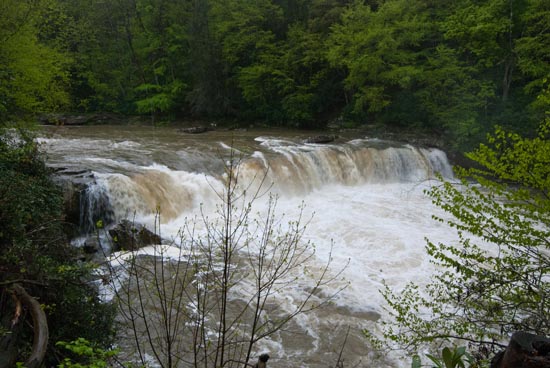
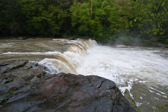
There is a clearing above the falls that is obviously used as a party spot. The gate and signage is probably because people leave their trash all over. Some of the trees and shrubs have been cut down to provide a clear view of the falls. You can easily reach the edge of the falls, but there did not seem to be any easy way down into the gorge below the falls. It's very difficult to get to creek level here and only two places to view the falls through the trees. In low water, this might be different.
The above route is what was given to me a long time ago. I went that way and it is pretty rough. On leaving, having talked to some folks at the festival camping, we decided to go another route. This route is much nicer, shorter, and easier. It begins with pavement and ends with a one mile, moderately rough dirt road. At the end you will cross two bridges. One at Sovern Falls and then Big Sandy.
From Exit 23 on I-68, drive south on N. Preston Hwy (WV 26) for just under 2 miles and turn right on Pleasant Valley (CR-26/16). Follow just over a mile to a fork in the road. Bear right at the fork onto Little Sandy Rd. (CR-14/3) and follow for 2.6 miles. Take a hard right onto Rockville/Mt. Nebo Rd. (CR-14). You are now on a dirt road. Follow for just about one mile. You will drive by a house on your left, cross the bridge and park to see Sovern Falls. You can see the falls from the bridge. Continue down this road a bit more and cross the bridge at Big Sandy Creek and park down to the right for Wonder Falls.