

Summersville Lake
Pirates Cove
(38.24313, -80.8486)
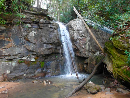
Drive 21 miles north of Fayetteville on US 19. Just after you go over the bridge, on your right is a parking area for the lake. It's the climbers access area. Hike the trail down to the lake. Some also call this Bastards Cove or Salmon Run. The trail starts out in open fields but after awhile begins to become forested. You'll come to a fork. Stay to the left and downhill. Keep following the blue blazes and eventually you will come to some funky stairs made of wood beams and mud. You are close now. Go across the creek and to your right. By now you should be able to hear the falls pictured below. There's an old wood ladder to climb down, but that has recently been superceded by some nice new galvanized stairs which will take you down to lake level and a good view of the falls. However, this is aparently not the Pirate's Cove waterfall here at the stairs. To get to Pirates Cove, you need to go down to the waterline and hike back toward the highway (west) and it should be around the big rock outcropping by about 400 hundred yards. I suppose you could take the right fork early in the trail, but then you would have to get down somehow.
These are the instructions I found on the climbers website Mountain Project.com: If you follow the link you will find a .gpx file of the trail which you can download.
Follow the trail from the parking lot. The first main fork in the trail will give you an option of going more or less straight, or veering off through a shallow gulley to the left. Take the left option. The next few forks stay to the right. Eventually the trail starts heading slightly downhill and you'll reach a trickle of a stream on some rocky surface. Keep following this until you reach the wooden ladder.
The image below is not at Pirates Cove, but at the ladders that take you down to water level.
Whippoorwill Falls
(38.2338, -80.8552)
From the New River Bridge, drive 19 miles. Take Hilltop Drive/Whippoorwill Road on your left. Follow paved road almost to the end (100 yds.). There will be a driveway with no tresspassing sign and then a dirt road on your left and a historic cemetary at the end of the road. Park at the dirt road and follow the dirt road until you reach a fork and take a left. Travel this trail past a campsite, down and left. Cut down the steep, often muddy hill to the lake. OK, I followed these instructions to the letter and there was no waterfall, but a nice grotto at lake level between some cliffs. It's very pretty, but no waterfall. I'll be asking around about it but if you know something, please let me know.